

Issue 19: Google Maps Cycling Directions should show accurate and practical routes through intersections
Summary: The feasibility, safety and convenience of navigating road intersections on a bike is a major factor in identifying practical routes. Unfortunately, Google Maps Cycling Directions often have various deficiencies in their intersection routes:- Sometimes the cycling (and often walking) route is wildly incorrect and dangerous. While pedestrians can often figure it out on the spot, cyclists following Google's directions may be led into danger.
- They often suggest using the same path as motor vehicles even when most cyclists use safer options
- They often ignore cycling-specific intersection facilities or rules (recommended bike pathways, contra-flow sections, gaps in barriers, hook turns)
- When they do leverage pedestrian crossings and paths these "Walk your bicycle" sections are not obvious on the map (ideally "walk only" sections should be in a different colour)
- They often recommend cyclists take circuitous routes including multiple pedestrian/bike crossings
- Informal shortcuts are ignored even if most cyclists use them

Details:
1. Google's Cycling Directions can suggest cycling (and walking) routes that don't exist, are illegal and dangerous
Because Google's Cycling Directions rely on automated calculations using incomplete data, and often have to leverage pedestrian facilities, they can turn out to be wildly incorrect - particularly for irregular or complex intersections. On an exception basis, it is necessary for humans to correctly map these cycling and walking routes. Currently, this is almost never done.
For example, the below irregular intersection between Queens Parade and Grant St does not allow motor vehicles to travel from Grant St to Smith St. It does allow pedestrians to. And cyclists can also use these pedestrian facilities if walking their bikes. Google Maps Cycling and Walking Directions are way off here as some zigzagging is required that a computer can't reliably figure out:

Inaccurate Google Maps Directions are easier to see using TripGeo's step-by-step Street View animation. You can see how they incorrectly direct cyclists and pedestrians into head on traffic.
The actual route is complicated and requires crossing three signalled pedestrian crossings:

The main issue here isn't that regular cyclists can't figure this out and get by or avoid it. It's that the current Cycling Directions and Cycling layer do not convey the indirectness and inconvenience of this intersection.
2. Google Maps often ignore cycling-specific intersection facilities or rules (recommended bike pathways, contra-flow sections, gaps in barriers, hook turns)
A critical use of cycling maps is finding out whether it's possible to cross an intersection in one's desired direction and, if so, determining the best way to do so. Pedestrians and cyclists often have specific facilities enabling them to cross intersections that don't apply to motor vehicles.
For example, Newry St is a key east-west bike arterial in the inner north of Melbourne. Google Maps Cycling layer has a continuous green line for the entire length of the street - including marking a short shared path at Station St as a Bicycle-friendly road, as bikes can cross here but cars can't.
However, there is one break in the line that incorrectly implies that cyclists cannot feasibly, legally or conveniently cross Nicholson St:
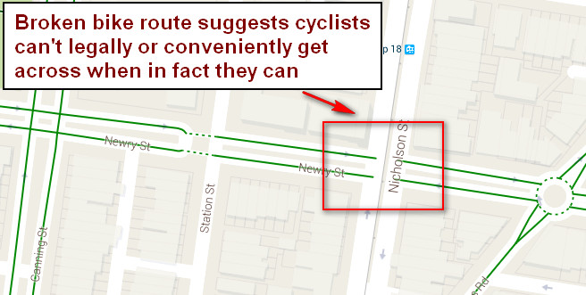
In reality, while motor vehicles are prohibited from continuing on Newry St here, there are small gaps in the concrete tram barriers specifically designed to allow cyclists to ride through.

Google Maps Cycling Directions consequently get this wrong and indicate cyclists having to use the bike-unfriendly Nicholson St to perform a U turn to continue along Newry St:

3. Google Cycling Directions often recommend circuitous routes for cyclists when there are more efficient alternatives actually used by most regular cyclists
By relying on automated route calculations based on Cycling layer data, Google Maps often shows very indirect and circuitous routes when there are quicker and more convenient alternatives actually used.
For example, turning right from St Georges Rd to Charles St, Google Maps Cycling Directions offers the following route:

Yet cyclists can easily turn right directly onto Charles St just as motorists do:

Share story


